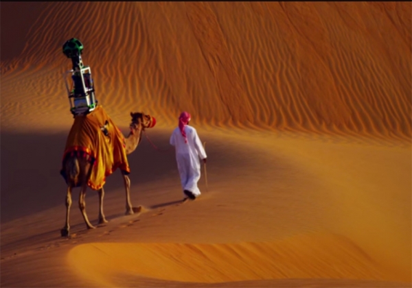
Google Uses Camel in Liwa Desert for Street View Map
Google has thought up a lot of creative ways to capture all the hard-to-reach places for its Street View map. First, it mounted its camera on cars, but on the trails of New York City’s Central Park, cars are not allowed, so Google rigged its Trekker cameras to bicycles. However, when Google decided to bring Street View to places like the Grand Canyon and the Great Barrier Reef, it developed hiker-friendly Trekkers that can be strapped to backpacks and go underwater.
For recording the Liwa Desert, 150 kilometers southwest of Abu Dhabi in the United Arab Emirates, Google found a whole new way to take 360-degree views of the desert that surrounds the Liwa Oasis, one of the largest oases located in the Arabian Peninsula and known to be the home of several Bedouin settlements.
Meet Raffia, the 10-year-old camel Google tasked to bring Liwa Desert to Street View and allow users from around the world a virtual experience of the desert’s rolling sand dunes as well as the date farms and the four-star Tilal Liwa hotel that lets travelers dine, rest and take a refreshing dip in the Jacuzzi after a weary day under the prickly Arabian sun. Securely strapped on top of Raffia’s hump is Google’s huge panoramic Trekker as he and his guide set out at 6 a.m. to capture the sights of Liwa Desert under the clearest possible weather conditions.
Joyce Baz, spokesperson for Google Middle East and North Africa, says enlisting the help of Raffia in its mapping missions is more than just a gimmick. She says Google wants to provide viewers a real sense of what it is like to travel through a desert sitting on top of a camel, the traditional mode of transportation that has been used in the area for thousands of years.
“With every environment and every location, we try to customize the capture and how we do it for that part of the environment,” Baz tells the local media. “In the case of Liwa we fashioned it in a way so that it goes on a camel so that it can capture imagery in the best, most authentic and least damaging way.”
Liwa is the third UAE location to be available on Street View, with the other two being the Sheikh Zayed Grand Mosque in Abu Dhabi and the Burj Khalifa in Dubai, the tallest building in the world. Baz says including Liwa in Street View will help bring more tourism in the area since 20 to 30 percent of all views come from outside the country. She also says that the ideal for Street View is to map the entire country in 360-degree-view.
“Ideally, we want to capture all of the UAE,” she says. “We want obviously all countries, because there is so much history and culture and heritage. I think it’s just a matter of time before we move to the other countries in the Middle East.”
Some parts in the Middle East, including the Great Pyramids of Giza and the historic town of Nazareth in Israel, are also on Street View.
To view the full article Click Here.

